¶ GeoJunxion
Your content here
¶ Products
¶ Digital Maps
Digital Maps is a vector map product that features global coverage.
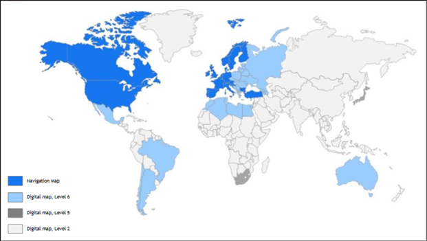
Coverage Levels
Digital Maps offer worldwide coverage, but the detail level per country varies. There are three progressive levels of road detail:
Level 2: Main roads only.
Level 5: Main roads, plus major roads through cities (connecting neighborhoods).
Level 6: All roads, including the most local roads.
Data Structure
Maps are divided on a per-continent basis.
A continental dataset labeled with a level (e.g., “Europe - Level 6”) signifies that at least one country or area within that continent is mapped to that detail level, not necessarily all.
The global world map is a combined delivery of all continents and includes the Poles dataset.
This product is updated twice yearly.
H1 delivery is end of June
H2 delivery is end of December
¶ Eco Alert Zones
¶ GeoAccess
GeoAccess is a service that very quickly and accurately plans the most optimal route between one or more locations. GeoAccess has been used for calculating travel distances within the Netherlands, Belgium, Luxembourg, and boarder regions of France and Germany for e.g. declaration purposes of the exact kilometers.
This product is updated on a quarterly basis.
The area covered for GeoAccess is The Netherlands, Belgium, Luxembourg, Northern France and Western Germany.
¶ Last Mile Maps
Last Mile Maps is a hyper local Map of the last mile for visitors.
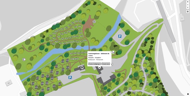
Last Mile Maps is a specialized service that provides detailed, interactive mapping for defined infrastructure such as stadiums, camping grounds, and fairgrounds. This product was known as an outdoor venue plan in the past.
Using high-resolution satellite imagery, we digitize the desired location to create a custom, interactive map layer. This platform delivers two core functionalities:
Advanced Routing: Our integrated routing engine generates live direction maps, guiding end-users accurately to their final destination—whether it’s a specific camping spot, a stadium entrance, or a vendor booth.
Interactive POIs: Enhance the map with dynamic drop-down menus and points of interest, providing users with valuable information about the spaces they are navigating. This portion of the project
This creates a hyper local map of the “last mile” that needs to be bridged by visitors, since usually the routing maps only bring you to the entrance of buildings. Each product is customized for the specific use of the client and can be adjusted according to requests.
The map can have little or many features, such as:
- Customized and Interactive Maps
- Interactive POIs
- Routing and Wayfinding
- Search Functions
- Tailor Made Content
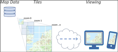
¶ Tile Server
These maps and their tiles are generated from our map database and are delivered on API request to end-users. GeoJunxion uses a combination of methods that make this service very fast and efficient. The map service comes with on-demand tile rendering, often with smart-tiling, and custom styling. With smart tiling, all populated areas can be pre-rendered to fulfill super-fast response to map requests.
Generally, GeoJunxion hosts the service for their customers but depending on the request customers host themselves at times as well.
Customization
Each tileserver version can be completed with multiple different options:
- Map presentation style: The OpenStreetMap (OSM) tile server contains map data of the World in the requested presentation style. Map tiles will be generated in this style for all zoom levels.
- Grey Scaling: In this delivery, Grey Map Tiles have been added, for a minimalist design.
- Tiling: This is a process where three methods are combined for efficient map delivery: (1) standard pre-rendering of zoom levels 0 through 12 (World, continent to county and province level), (2) smart tiling, a process in which more detailed levels until 18 are pre-rendered for the most populated areas, and (3) on demand tiling and rendering for remaining less data dense areas. As a result, the map tiles of high-density data areas are returned much faster than when rendered on the fly.
- Photon: Photon Search Service has been added to the delivery, to be worked on on-premises, to add advanced geocoding. Supported functionalities: search, and reverse geocoding.
- Language: A specific language can be selected to display on the map, or it can be set to local language.
This product is updated twice yearly.
H1 delivery is end of July
H2 delivery is end of January
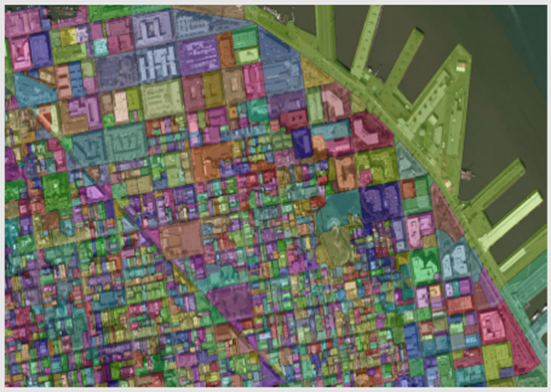
¶ Zip+4
This dataset covers the entire USA and contains ZIP+4 code polygons that are largely based on parcel areas and road geometry. A ZIP+4 code polygon defines the area within which a group of addresses share acommon ZIP code. In the USA, the ZIP code consists of ZIP5 and Zip+4.
The image below shows the Zip5 areas of San Francisco.
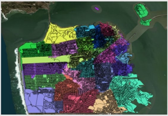
The image below shows the Zip+4 areas of downtown San Francisco.
Below are the attributes of the data.
| Field | Description |
|---|---|
| ZIP | Five-digit ZIP code. (field data type ‘string’ and field length 5) |
| PLUS4 | Additional four-digit ZIP code. (field data type ‘string’ and field length 4) |
| OVERLAP | Flag to mark overlapping zip4 code polygons with different ZIP+4’s; values ‘t’ for true and ‘f’ for false. (field data type ‘Boolean’ (t/f/NULL)) |
| FIPSSTCO | Federal Information Processing Standard (FIPS) State code + FIPS County code. (field data type ‘string’ and field length 5) |
| STATE | State abbreviation according two letter state codes defined by USPS http://pe.usps.gov/text/pub28/28apb.htm. (field data type ‘string’ and field length 2) |
No releases are planned for this product at this time but can be requested.